Friday, December 30, 2016

More ‘found’ clean energy haiku and haiga

Saskatchewan Crossing
Watercolour and Photoshop™
©2016 Charlene Brown

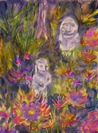
Saskatchewan Crossing is the tenth picture I’ve produced for my ‘clean energy’ haiku project using computer-stylized versions of Canadian landscape paintings.  I plan to expand this Haiku+Haiga series into a compilation of up to 50 poems. And I may even try to explain some of the non-sequiturs in the poems! 

Haiku: a poem of seventeen syllables, in three lines of five, seven and five syllables, traditionally evoking images of the natural world

Found clean energy haiku: five or seven syllable phrases found in environmental research publications or newspaper articles on climate change.

Haiga: a style of painting that incorporates the clean, minimalist, yet often profound, aesthetic of haiku.


Friday, December 23, 2016

Travels with Our Grandkids II (d) – Maui

Finally the high point of Danny’s time in Hawaii, and the excursion I’d been worried about all week, arrived! A bus picked us up at the dock in Kahului, then we rode the bus to the rim of the Haleakala Volcano (elevation well over 3000 metres) pulling a trailer full of bicycles. 


Here we are just before sunrise, getting ready for the 38-kilometre descent. Yes, it was every bit as cold as it looks, but the ride down – past lava rock, five distinct layers of weather, rainbows, waterfalls, and huge jacarandas, to a spectacular surfing beach (by which time we were out of this industrial-strength rain gear) – was wonderful! 

And here's what the crater looks like.  Parts of it look like it just blew up, but apparently it's been dormant (not extinct) for about 400 years.

Sunday, December 18, 2016

Travels with Our Grandkids II (c) – Maui

Just about the first thing we did when we got to Maui was take a helicopter tour of the deep valleys carved into the West Maui mountains – virtually inaccessible by any other means.

This painting shows several waterfalls as seen looking straight down through the side window as the steeply-banked helicopter circled a valley rim.  It was not done on location.


Wednesday, December 14, 2016

Travels with Our Grandkids II (b) – Hawaii, the Big Island


Here we are arriving at Kona, our second port, on the Big Island of Hawaii. Kona doesn’t have docking facilities for large cruise ships so it’s necessary to go ashore in tenders (actually a couple of our ship’s lifeboats).
As luck would have it we disembarked just as hundreds of lean and lanky athletes dashed into the water on the first leg of an Ironman triathlon – a 2.4 mile swim in Kailua-Kona Bay (to be followed by a 112 mile bike ride across the Hawaiian lava dessert and a marathon run along the coast).  It wasn’t the famous Kona Ironman World Championship, which is held in the fall, but they all looked like champions to us.


Also on the Big Island, we toured the previously mentioned lava beds, including walking through a huge lava tube in Hawaii Volcanoes National Park, and Danny even agreed to participate in a precipitous hike through a spectacular botanical garden… on condition that I go for a very scary bike-ride on our second last day… or maybe I agreed to go on the bike-ride only on condition that he see the garden. 

Wednesday, December 7, 2016

Virtual Paintout in Montenegro

Islands in the Boka Kotorska
Watercolour
Charlene Brown


I painted and wrote about several locations in the Balkans a couple of years ago, including three in Montenegro. Two of these, Stari Bar and Kotor, I’ve just discovered can be located in Google Streetview – click here for Stari Bar and click here for Kotor.      


Sunday, December 4, 2016

Travels with Our Grandkids II (a) Kauai

My next trip, with our second grandson Dan, was the only one that didn’t involve an organized intergenerational tour in the summer during the school holidays. Dan wanted to go to a warm place before the end of winter in Calgary, so we selected a cruise around the Hawaiian Islands in March of 2005.

After our flight to Oahu and evening cruise departure from Honolulu, we woke to find ourselves in the beautiful port of Nawiliwili on the island of Kauai. This northernmost island in the Hawaiian chain is very rugged with deep valleys and sharp mountain spires draped in lush tropical rainforests. Much of it is only accessible be sea or air.

It is also the least developed or ‘touristy’ of the major islands but we managed to find a shop with the mother lode of t-shirts depicting the spectacular Na Pali coast – the cliffs and waterfalls of which are among the sights best viewed from the sea. So we bought the t-shirts before we’d actually ‘been there, done that’ … Later that day, when we set sail for our next destination, The Big Island, we finally had the ‘best view’ of the Na Pali Coast.

Monday, November 28, 2016

Travels with Our Grandkids I (f) – Costa Rica

Costa Rica

Mother and daughters
Decorative Mayan-themed sculpture
©2016 Charlene Brown


This painting is based on a photograph I took in the bromeliad garden of our hotel in San José

The Mayan civilization, which flourished in MesoAmerica until the arrival of the Spanish in the early 16th century, extended to this area, but there is only one major Mayan archaeological site in Costa Rica, the Guayabo National Monument.  Some artifacts have been found and Mayan decorative themes are popular.

Friday, November 25, 2016

Travels with Our Grandkids I (e) – Costa Rica (with a preview of Peru)

The picture of Phil on the left marks the beginning of my fascination with the Spanish spelling of Extinguisher, a fascination not shared by the various kids I photographed over the years. I’ve included a picture of Phil’s cousin Nick, taken five years later in Peru, to show I did manage to get other shots before people started working together to prevent me from noticing Extintor signs in various Latin American countries.


I have one more painting of Costa Rica that I’ll post in a few days before moving on to my second trip with Phil’s brother Dan, the following year.

Saturday, November 19, 2016

Travels with our Grandkids I(d) - Costa Rica


The roads in Costa Rica are lined with these lovely living fences, which surround most of the farms. The reason for using trees, strung with three or four lines of wire, to fence the land is very simple – the ubiquitous termites don’t eat live wood. The established fences, lobbed off many times so the wire stays close to the ground, are mainly gumba limbo, but the younger in-fill trees are sometimes more flamboyant plants, such as hibiscus or poinciana – though not usually in full flower as shown here. Don’t you agree the whole concept is wonderfully paintable, along with the chain of volcanoes that forms the backbone of the country? 
I first saw these fences on the 2004, but didn’t have my camera ready ­­– being preoccupied with the warning from our driver that we could either get up the hills or have air conditioning.  I painted this picture several years later following a 2010 Panama cruise, when I knew where to have my camera ready as we climbed toward the mountains. 

Monday, November 14, 2016

Travels with our Grandkids I(c) – Costa Rica

Eco-system in a Tree
Watercolour pencil and ink sketch
©2004 Charlene Brown

Everything you see and hear becomes a lesson on a Road Scholar trip, and our hike in the cloud forest was no exception. We were getting used to the idea that plants we would consider houseplants back home can be as big as a house in the tropics, and in the case of this ficus, can support a whole ecosystem! There were many plants in addition to the ones shown here, to say nothing of the animals – mammals, birds, reptiles, insects… everything but fish, I think.


Wednesday, November 9, 2016

The Virtual Paintout is in Tijuana, Mexico this month


Jesus Pérez, Rosarito
Oil pastel and watercolour
@2016 Charlene Brown


The Virtual Paintout is in Tijuana this month  When I first sketched this Google Streetview in the suburb of Rosarito, the whole thing looked surprisingly off-balance... what to do? 

If you click on this link, you will notice a blue building on the far left.  It looks like this if you move down the street to view it from the front. I’ve moved it to the right side of the picture, to get around the balance problem.

Saturday, November 5, 2016

Travels with our Grandkids I b – Costa Rica

Here’s Phil with a traditionally-decorated Costa Rican ox-cart.  I don’t have any drawings or paintings that include any of these extraordinary little vehicles, as I wouldn’t dream of undertaking something so complicated.  Phil would (and still will) and I think he drew and painted a picture of this one – but I didn’t have the presence of mind to grab his picture for my ‘collection.’  

Saturday, October 29, 2016

Travels with our Grandkids I

 El volcan Arenal 
 Ink and watercolour pencil, annotated page in 4”x 6” Opus Archival drawing pad
 ©2004 Charlene Brown

Over the next few months, I plan to compile stories, photos and paintings from the trips I took with our six grandchildren (one at a time!) between 2004 and 2013.

This annotated sketch is from an Elderhostel (now Road Scholar) Intergenerational trip to Costa Rica with our eldest grandson, Philip, in 2004. We both enjoyed all the activities planned for both age groups, but agreed that the Arenal volcano was the highlight of the trip. And we had a great view of it from our hotel a short distance up the mountain slope just across the valley. 

Sunday, October 23, 2016

Can you guess where this is?

Yukon

Kluane Icefield
Watercolour and crayon
©2016 Charlene Brown

I think that my first guess would have been that this icefield was in Switzerland. But the name reveals its location in Yukon, part of the bi-national Kluane-Wrangell-St. Elias-Tatshenshini-Alsek park system stretching from Glacier Bay in Alaska into the highest mountains in Canada.
This spectacular icefield is relatively unfamiliar because this view point is almost inaccessible  (at least when compared to glaciers in Switzerland you can get to on a train) despite being less than twenty kilometres from the Alaska Highway!
I should probably mention that the chartreuse arctic poppies I’ve added may not actually grow in Yukon.  They are native to the northermost parts of Scandinavia and the only place in Canada I’ve ever seen them is Pangnirtung in Nunavut.


Saturday, October 15, 2016

Virtual Paintout still in Newfoundland

L’Anse aux Meadows Newfoundland and Labrador
L’Anse aux Meadows National Historic Site
Watercolour and crayon
©2016 Charlene Brown

L’Anse aux Meadows dates from the early 11th century.  It is the first and only known site established by Vikings in North America and the earliest evidence of pre-Columbian transoceanic contact and European settlement in the New World.

The reconstructed sod longhouse in the painting is patterned after the remains of wood-framed peat-turf buildings excavated at the site.  These remains were similar to those found in Norse Greenland and Iceland built in the same period about 1000 years ago. 

It was named a UNESCO World Heritage site in 1978.

Here is the link to the Google Streetview of the site.


Friday, October 7, 2016

This is my 100th Virtual Paintout!

St. John’s Harbour from Signal Hill
Watercolour and crayon
©2016 Charlene Brown

The Virtual Paintout is making one of its rare excursions into Canada this month – to the island portion of the province of Newfoundland & Labrador. 

Signal Hill was the site of St. John’s harbour defences from the 17th century to the Second World War, and where Guglielmo Marconi received the world’s first transatlantic wireless signal in 1901.  It’s a great place for hiking, and even better for motoring around in the Google car or whatever they used to find this Streetview. Here’s another view of St. John’s from the gun emplacement in the centre of my painting. They must have used something besides their car to get to that one.

Monday, October 3, 2016

This is my 500th blog post!

Gabriola Island
Entrance Island Light
Watercolour and crayon
©2016 Charlene Brown

The latest artist studio tour for our fundraising group from the Art Gallery of Greater Victoria was to Gabriola Island, about a twenty-minute ferry ride from the up-island city of Nanaimo. As always we visited several fascinating and productive (and idyllically-situated) workspaces – two of which are included in the mix in this painting.

The Entrance Island lighthouse off the northern tip of Gabriola, has been there since 1876. Situated so close to Nanaimo, it has watched over thousands of boaters and kayakers, and for many years the annual flotilla of bathtubs in a race to Vancouver.  The lighthouse keepers have rescued many in distress, regularly saving lives over the years, and the boating community, in turn, keeps its eye on the lighthouse.  In 1995 when it was announced that Entrance Island might lose its keepers, more than 100 kayakers, in an act of protest, formed a ‘human life preserver’ around the island. Since then, almost every newly-elected Provincial and Federal government has included this integral part of the Gabriola Island community in their budget-cutting  plans... but the lighthouse keepers carry on.


Monday, September 26, 2016

Art Extravaganza by the Sea

Sketch of  ‘Mother and Child’ stone sculpture by Mike Rebar

On the weekend of September 17-18 the coastal walkway at Macaulay Point in Esquimalt was transformed into a seaside open-air gallery of 3-dimensional art – the Third Annual Sculpture Splash. 

This larger-than-life-size carving by Mike Rebar, in the style of the Inuit, was among my favourites.

From Mike’s website,  I learned that he sculpts local marble that he harvests from various sites on Vancouver and Quadra Islands.  He sees the integral form of each piece inside the stone, then works with traditional handtools, carbide chisels and diamond blades until his vision emerges.  Fine details are achieved with hand files followed by wet and dry sanding to complete the process... worth contemplating on the days when watercolour painting seems like too much of a challenge.


Monday, September 19, 2016

Virtual Paintout in Lancaster County, PA

Lawn sale day in Terre Hill
Watercolour and crayon
©2016 Charlene Brown


Here’s a link to the right side of ‘Lawn sale day in Terre Hill.’  I wanted to add some houses and lawns from further down the street, so I used my panorama format sketchbook.  

I began this sketchbook in Japan and this Virtual Paintout seemed like a good opportunity to start filling the rest of the pages.


Wednesday, September 14, 2016

Finding strategic clean energy haiku

Johnston Canyon
Watercolour and Photoshop™
©2016 Charlene Brown

There are more and more articles online and in print media about the environmental and economic aspects of climate change. Such articles, predicting future harmful effects and advancing strategies for mitigating and preventing them, are good sources of ‘found’ clean energy haiku.  

And new or once known but now forgotten phrases – particularly scientific or technological terms you have to look up in Wikipedia – make the best ‘strategic’ found clean energy haiku.

For example, the first two lines in the poem on the Johnston Canyon picture:

eponymous laws
primordial gravity
divide and conquer

are a little less enigmatic if you Google:

eponymous laws: Many scientific phenomena are defined by eponymous laws or principles or rules, named after the person who first discovered or defined them – Avogadro, Newton, Mendel, Planck – and most of us can’t remember most of them (with the notable exception of Murphy, whose law everyone remembers).

primordial gravity:  The existence of primordial gravitational waves (ripples in space-time that originated in the very early universe or Big Bang) could reconcile general relativity and quantum mechanics to reveal a ‘theory of everything.’


They still don’t make a lot of sense, but they are less enigmatic. 

Wednesday, September 7, 2016

Really old climate records

The Burgess Shale
Watercolour and crayon
©2016 Charlene Brown

The Burgess Shale was discovered by paleontologist Charles Walcott in 1909 high on a ridge above Emerald Lake in Yoho Naitonal Park.  He was so impressed with the extent and diversity of the layers of fossils, that he returned over a dozen times, finding more life forms every time. Over the years since Walcott’s discovery, the Geologic Survey of Canada and the Royal Ontario Museum got involved and many additional outcrops have been found, stratigraphically both higher and lower than the original. These localities continue to yield new organisms faster than they can be studied.

The Shale has attracted the interest of paleoclimatologists who are studying fossil records that appear to show a rapid acceleration in the diversification of complex organisms during the Cambrian Explosion.  This evolutionary event was a short period half a billion years ago, during which most major phyla in existence today appeared.  When researchers understand the climate of that period and its effects, they may be able to predict long-term future effects of climate change on species diversification and extinction.

Wednesday, August 31, 2016

One more for the Bucket List

Ballooning over Bagan
Watercolour and crayon
Charlene Brown

As I mentioned in a post at the beginning of this month, I’m starting a ‘Bucket List’ PinterestBoard. Several of my Virtual Paintout paintings – of places I haven’t been to but would like to see – have found their way onto this board, and there will be paintings of photos, like this on in Myanmar, that I've come across on the internet – often on other people’s Pinterest Boards.

Apparently, this fantastic sunrise shot can only be obtained from a hot-air balloon and it seems to be impossible to take the picture without including all the other folks out in balloons doing the same thing.  I could have left them out of the painting, of course, but chose not to.  And I’ll probably include a sunrise hot air balloon ride in my itinerary when I eventually get to Bagan…  I’ve tried ballooning a couple of times, in Sedona, Arizona and the Masai Mara in Kenya, and it is truly an other-worldly experience. 

Update: There were several casualties, including at least four fatalities, and many of the temples, pavilions and pagodas were damaged in the earthquake that hit Bagan a week ago – a sad set-back in the on-going restoration of this UNESCO World Heritage site.


Wednesday, August 24, 2016

Even more haiku and haiga

Mt. Lefroy
Watercolour and Photoshop™
©2016 Charlene Brown

You might think, because I’ve used this particular verse before, that my haiku-generating computer has limited content to work with.  Not at all – so far I have input over 200 lines, with literally thousands of possible three-line combinations, and I find more material just about every time I read a newspaper or magazine or online article on environmental or economic aspects of clean energy technology development.

The thing is, I may compile samples of this clean energy haiku into a book, and I will only be using Canadian landscapes for the haiga illustrations. This particular haiga is a computer-stylized version of a painting I wrote about two years ago

Wednesday, August 17, 2016

More ‘found’ haiku and computer-stylized haiga

Whistler Village
Watercolour and computer
©2016 Charlene Brown

This is a continuation of a series I began a year ago, consisting of computer-generated haiku poems and haiga illustrations. 
The poems  (actually haiku-like non-sequiturs) have three lines, containing:
     . a clean energy-related concept (5 syllables)        
     . a tangentially related environmental or economic concept (7)
     . a transformation (5)
The haiga illustrations are computer-stylized versions of some of my Canadian landscape paintings.
I’ve set up a new PinterestBoard about Clean Energy Haiku. The pin descriptions aren’t filled in yet, but if you have a minute, check out this board anyway – I`ve added some clean energy haiku from THE ENTIRE IPCC REPORT IN 19 ILLUSTRATED HAIKU, by Anna Fahey, ©2013 Sightline Institute, Seattle; used with permission. Unlike my ‘found’ non-sequiturs, these are actual haiku verses!
Wednesday, August 10, 2016

Virtual Paintout still in Norway

The Bridge at Tromso
Watercolour and Photoshop™
Charlene Brown

Tromso is quite close to Bleiksv, one of the other locations I painted in Norway.  They’re only about 100 km apart, but between five and six hours driving time, depending on the ferry... not unlike getting from here in Victoria to Vancouver on the British Columbia mainland. Tromso is considered to be the northermost city (population over 50,000) in the world.

This Streetview of Tromso includes the Arctic Cathedral, which can be seen just to the right of the bridge.  It is called a cathedral just because it looks like it should be one, but is in reality a parish church. 

Sunday, August 7, 2016

Virtual Paintout in Norway

Ringebu stave church, Oppland
Watercolour and crayon
Charlene Brown
Bleiksv, Nordland
Watercolour and crayon
Charlene Brown

The Virtual Paintoutis in Norway this month.  I’m putting both into one blogpost because I think they go together and could be considered a pair of paintings of Norway, even though the first one is in the mountains just north of Oslo, and the second is much further north (24 hours driving time, according to Google maps!) on the seacoast. 

I painted another location in Norway, but that picture is totally different from this ‘set’ and I’ll post it separately.